Villa de Leyva


Villa de Leyva, Boyacá, Colombia
Suggest Place to Visit
2766
Track to location with GPS |
 |
Founded on June 12, 1572 by orders of Don Andrés Díaz Venero de Leyva, first president of the New Kingdom of Granada, Villa de Leyva is one of the most beautiful colonial towns in the country, it is located at 2,145 m.a.s.l. It has an average temperature of 18 ° C. Due to the action of the colonizer, in less than a century the valley lost two thirds of its indigenous population and began to erode rapidly, until today recalling certain semi-desert landscapes of Castile, with its ocher and olive groves, around the beautiful roofs of the town. Its gigantic main square and its totally cobbled streets are lined by old colonial buildings and old mud walls.
During the terrestrial Cretaceous, the territory that Villa de Leyva occupies was occupied by a primitive sea that, with the accommodation and tectonic development of the planet, gradually retreated giving rise to the creation of lakes and valleys that were finally shaped by the growth and emergence of the mountainous massif known by the name of the Andes. Upon reaching Colombia, in the south, this massif is divided into three mountain ranges: Eastern, Central and Western. The growth of these mountain ranges was completed more than 20 million years ago in the stages known as the Miocene and Pliocene. The abundance of life in these primitive seas is what explains the geological and paleontological richness of these lands.
In the surroundings of the town there are thousands of fossils, in fact many floors and walls in old buildings have fossils in their finishes; however the most prominent finds so far are a chronosaur currently on display in the fossil museum, and three pliosaurs that are in the study and recovery phase.
Precolumbian era
The first traces of inhabitants in the area date back more than 2,500 years and are found in several places, the most striking is known as the little hell that groups monoliths and an old tomb, although the theory that it was an old observatory is maintained astronomical, there is currently talk that it was actually a cult site or even a point of passage for material to other locations. Also in the area are other remains such as cave paintings and petroglyphs.
The Muiscas occupied the Cundiboyacense highlands. (Cundinamarca, Boyacá and Santander) in an area of 30,000 km2. They were an essentially agricultural people, whose diet was basically vegetarian. They were potters and extraordinary goldsmiths specialized in the elaboration of personal ornaments and representations of gods, sacred animals and beings from aboriginal mythology.
The upper area of Villa de Leyva in which the páramo and the Iguaque lagoon are located played a fundamental role in the culture of this town since its cosmogony is based on this lagoon:
Myth of Bachué or the creation of humans: A beautiful woman came out of the Iguaque lagoon carrying a child carried on her right arm, this woman called Bachué or Furachogue went with the child into the forest without the name being known of the infant. Years passed until the boy became a man and joined Bachué, in this way they were having children who populated the Earth; Once her mission was accomplished, she returned to the waters of Iguaque accompanied by her companion and now they are in the depths of the lagoon.
The conquest
Once the Spanish conquerors arrived, they entered the territory of the Muiscas who offered very little resistance, behind the horses and the predation the evangelizers arrived in the area where they built a temple around the year 1533 of which today are the ruins, This temple was abandoned due to indigenous migration caused by the poverty of the soil and the shortage of food.
The solemn act of foundation of the Villa de Santa María de Leyva was signed on June 12, 1572 by Don Hernando Sánchez de Villalobos, Lieutenant Corregidor and Chief Justice of the city of Tunja, the mayor of Tunja, Miguel Sánchez and the Perpetual Regidores Francisco Rodríguez and Diego Montañez, ´´in compliance with the commission and orders provided by his honor the president´´, of the Royal Audience of the New Kingdom of Granada Andrés Díaz Venero de Leyva.
The arrival of new settlers and cultivation techniques allowed restarting large-scale agricultural work, where the main product was wheat and for whose processing a large number of mills were built, this led the Villa to be the main producer of wheat in the The country during the 16th and 17th centuries. However, the poor use of the soil, its quality and the lack of rotation techniques progressively led to a depletion of the soil so severe that a large part of the land in the area is not suitable for cultivation. During this time, Villa de Leyva was also a recreational site for officials and borrowers, in addition olive groves and divi divi trees were also cultivated, the fruit of which was used as a coloring for garments.
In 1811, after much effort and the creation of a revolutionary movement, Villa de Leyva achieved its separation from Tunja and on June 5 of that year it was declared an independent municipality. In 1812 the first congress of the united provinces of the new Granada was held there, where Camilo Torres was elected as president.
XIX century
The town was the headquarters of the First Congress of the United Provinces of New Granada, which was held on October 4, 1812, where Camilo Torres Tenorio was elected as President of the Federal Republic.
Twentieth century
In 1954 the government of General Gustavo Rojas Pinilla declared the Villa as a National Monument, issuing the rules for its preservation, at this time the road to Tunja was built and the paving of the square and streets that characterize it was made.
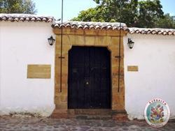
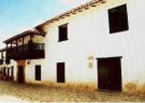
In Villa de Leyva architecture the colonial type predominates, but in the center of the town there are beautiful republican-style buildings, fortunately the samples of contemporary architecture are very scarce, which has preserved the historical charm of the area.
Villa de Leyva is a Colombian municipality located about 40 km west of Tunja, in the department of Boyacá, recognized as historical and cultural heritage, it is characterized by its colonial-style architecture and by its varied rural landscapes that go from the area of páramo with its births and water reservoirs to the desert and dry area.
It is located between the Serranías de Iguaque and Merchán, 2,045 meters above sea level.
VILLA DE LEYVA, is one of the most beautiful and best preserved colonial towns in the country. It was declared a National Monument in 1954.
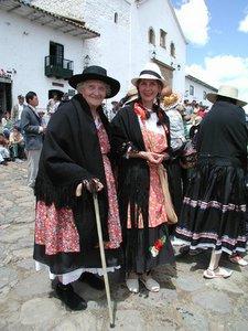
This beautiful town contains a sublime colonial era, through its cobbled streets visitors can walk and discover a gigantic main square, surrounded by streets that evoke bygone periods, through which there are old houses that have been converted into family hotels to accommodate the guests. tourists.
Villa de Leyva is an exceptional region within the spiritual and geographical panorama of Colombia. One of our oldest cities and therefore also one of the most beautiful traditions. And also of those that lavishly have given our history fruitful and enduring pages, now heroic now full of enchantment and nostalgia.
Its huge main square stands out, paved (14,000 m2) and flanked by old colonial buildings with their arcades, gates and balconies. Among the colonial buildings that are preserved are: the Cathedral Church, the Carmen Church, the Antonio Nariño Museum, the Antonio Ricaurte Museum, the San Francisco Convent, the Carmen Convent, the San Agustín Cloister, the Royal Factory of Aguardientes, the House of Congress. In addition, there are the Luis Alberto Acuña Museum and the Carmen Museum.
In Villa de Leyva you have the chance to really immerse yourself in the past, as several houses in the Colony have been converted into family hotels, with paved corridors and patios full of geraniums and bougainvillea.
The region around Villa de Leyva is abundant in fossils. The El Fósil museum exhibits a kronosaurus, in the place where its skeleton was found in 1977. The museum also exhibits a wide collection of fossils from the Mesozoic and Cretaceous periods.
In the nearby area are located the La Candelaria desert (located at 2,700 above sea level) and the La Candelaria monastery, in the municipality of Ráquira, and the Santo Ecce Homo Monastery, in the municipality of Santa Sofía, the blue wells (wells of water colored by the action of sulfur salts that are released within them).
In the upper part of the páramo, to the north of the town, is the Iguaque Fauna and Flora Sanctuary, a protected area that has six lagoons, among which the Iguaque lagoon stands out for its historical significance.
According to the mythologies of the Muiscas from the water of this lagoon, Bachué, the mother of the human race, emerged, along with a three-year-old boy, who when he grew up joined her.
Comments
We don´t have yet any comments about:
Villa de Leyva
Villa de Leyva
Be the first to leave a comment as it is very important to inform other people
Outros locais a visitar
Within a radius of 20 km from:Villa de Leyva
Casa Museo Antonio Ricaurte |
| 0,7 Km |
 |
Nariño's house |
| 1,1 Km |
 |
Hotel reservation near Villa de Leyva within a radius of 20 km
Why to book with TOURISTIC ROUTES
The best prices
Our partnerships with the world´s largest operators offer research on the best market prices.
More options
At Rotas Turisticos you can book the hotel, buy the air ticket, book the transfer from the airport to the hotel and vice versa, book the local excursions, rent the car, take travel insurance and consult the places to visit and where to go.
Holiday Tips & Destinations
Hundreds of holiday destinations with all the options that allow you to easily choose the destination that best suits your dream vacation.
TOURISTIC ROUTES
Links
Follow us on social networks


