Upala


Upala, Alajuela, Costa Rica

Suggest Place to Visit
1689
Track to location with GPS |
 |
In pre-Columbian times, the territory that currently corresponds to the canton of Upala was a territory under the dominion of the indigenous Votos, who in turn obeyed the famous chief Garavito. It has been determined that it was one of the best refuges for the natives who escaped from the Spanish given its remoteness from the ports and difficult access.
During the colonial period, some incursions by Spaniards through Nicaragua were attempted, which failed due to the difficult access and remoteness, as well as the ferocity of the indigenous people who inhabited, which is why from these failures total interest in entering said plains by the Spanish. It would not be until the end of the 19th century that people from places like Rivas and San Carlos de Nicaragua began to arrive, looking for the rubber tree that was abundant in the area to extract the product and trade it in their country until they began to settle in the middle of the virgin forest, very close to the rivers that allowed them to sell and buy products to their country through Lake Nicaragua; then they founded some tiny towns. Thus later they began the exploitation of the existing woods, and after settling down firmly they began to grow agricultural products for their consumption.
Later there was a second phase of migration, also from Nicaragua to the foothills of the Guanacaste Volcanic Mountain Range, but on a much smaller scale. Then they introduced the cultivation of cocoa that spread throughout almost the entire lower zone, which became the main activity for years until the plague known as monilia, which is like the equivalent of the coffee berry borer, except that it is a fungus; it wreaked havoc with the vast majority of crops. The first Costa Rican settlers arrived from the Guanacaste cantons of Cañas and Bagaces, towards the second decade of the last century, who in their effort to find new lands ventured into the mountains along the trails that the aborigines used in their journeys through the virgin forests. of the Guanacaste Volcanic Mountain Range, on the slopes of the Tenorio and Miravalles Volcanoes. At first they settled in the highlands, founding the towns that today are the district capitals: San Isidro de Aguas Claras and Bijagua; and thus gradually they came to the plains, meeting as a consequence with the other population that was of Nicaraguan origin and thus unifying the populations.
In 1911, the Executive Power, by agreement No. 289, changed the name of Zapote de Guatuso to Upala at the request of the settlers. On October 18, 1915, by means of executive decree No. 20, of the administrative territorial division, the population of Upala was established as part of the eighth district of the canton of Grecia, although it never had proximity or territorial, economic, or social with the same. In the administrative territorial division of the Republic, made on June 28, 1957, by means of an executive decree, the ninth district of the aforementioned canton was the Upala neighborhood and its towns. Until under the government of José Joaquín Trejos, by means of a resolution of the Legislative Assembly that approved Law No. 4541 on March 17, 1970, the canton of Upala was officially created and the title of Villa was granted. Then a new law, Law No. 4574 promulgated on May 4, 1970, establishes the Municipal Code, which gave the category of city to Upala, as it is the head of the canton.
In 1920 the first school located in the head was established, when the president of the country was Don Francisco Aguilar Barquero, currently the school is the main one in the sector and is called the Teodoro Picado Michalski leading school. The Upala Agricultural Professional Technical College was inaugurated in 1972, in the second administration of José Figueres Ferrer.
In the archbishopric of Monsignor Carlos Humberto Rodríguez Quirós, fourth archbishop of Costa Rica, in 1962 the parish dedicated to San Juan de Dios was created. Upala is currently a vicarage of the diocese of Tilarán, of the ecclesiastical province of Costa Rica (it should be noted that Upala is the only Alajuelense canton that is directed by the bishopric of Guanacaste: Tilarán in ecclesiastical matters when declining to belong to the diocese of Ciudad Quesada to which its neighbors Guatuso and Los Chiles belong)
On August 9, 1970, the first session of the Upala Council was held, made up of the proprietary councilors, Oswaldo Ramos Badilla, president; Tito José Somarribas Larios, vice president, and Vinicio Rojas Salazar, member. The municipal executive was Mr. Adolfo Rodríguez Solís, and the municipal secretary, Ms. Concepción Figueroa Oreamuno. At that time there were no furniture or equipment, Miss Concepción Figueroa who was a secretary lent her typewriter and a calculator, which to this day are preserved as a souvenir.
The first aqueduct of the canton was inaugurated in 1976 in the government of Mr. Daniel Oduber Quirós. The electric lighting was installed in November 1978, in the administration of Mr. Rodrigo Carazo Odio. For the name of the canton there are several theories such as the one that says that the word Upala is an indigenous voice of Nahuatl; from ulli: rubber, atl: water, bread: envelope; which means on or in the rubber river. Although other meanings are handled, the aforementioned is mostly accepted; What is certain is that it is a name derived from native languages.
Upala is the thirteenth canton in the province of Alajuela, Costa Rica. Its head and most important population is the district that bears the same name of the canton: Upala. It is part of the North North Region together with San Carlos (economic axis of the Region) Los Chiles (canton 14) and Guatuso (canton 15) and the Heredian canton of Sarapiquí. Its name comes from Nahuatl and means "near the river" or "big house near the river".
Upala is made up mostly of extensive plains that are around 50 meters above sea level, however in the districts of Aguas Claras, Bijagua and Dos Ríos (bordering Guanacaste and therefore with the mountain range of the same name) they present elevations close to 500 meters above sea level. its towns at the head of the district, and some sectors that exceed that height.
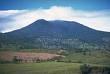
The canton is surrounded in its sector from South to Northwest by the Guanacaste volcanic mountain range (natural boundary between Alajuela and Guanacaste), having settlements on the slopes of the Tenorio Volcano, Miravalles Volcano and Rincón de la Vieja Volcano; from which several rivers of great importance in the development of the canton descend, such as the Niño or Pizote River, the Zapote River, the Guacalitos River among others of smaller size, as well as numerous streams and streams. There are also some small lagoons such as Las Camelias in San José (Pizote).
Upala is an eminently rural and agricultural canton (being one of the largest producers of beans at the national level), however its head has grown considerably from the urban plan and with it its employment options, to the point of having agencies of the three most important state banks (Banco Nacional de Costa Rica, Banco de Costa Rica and Banco Popular), financial cooperatives, MINAET, MAG, police bases, fire station, agency of autonomous institutions such as INS, IDA, CNP, IMAS, ICE, PANI. It also has a prosecutor's office and criminal court, and a hospital of great importance for its inhabitants. The EBAIS and educational center services are quite dispersed throughout the territory, with many schools and at least one school, telesecundaria or night school per district, however despite this there is still a significant lag in these areas due to the lack of personnel. bad communication routes or lack of infrastructure; negatively affecting their human development index.
Despite belonging to the province of Alajuela, its population maintains a greater relationship with the Guanacaste cantons, especially with Liberia and Cañas for commercial reasons and especially for health services, although it should be noted that in recent years the relationship has increased significantly. with San Carlos de Alajuela, as Ciudad Quesada is the main city and axis of the Huetar Norte Region and has practically all public services and greater employment options within a relatively short distance.
Finally, it should be noted that Upala has a large number of immigrants from the neighboring Republic of Nicaragua who, since the early years of the canton have been establishing themselves throughout the entire territory, for which a large percentage of the canton's population has Nicaraguan ancestry of distant or first degree.
Due to its relatively large territorial extension, the canton presents many factors such as the cool climate in the areas near the Miravalles, Tenorio and Rincón de la Vieja volcanoes, warm in the plains, a fairly high rate of rainfall throughout the year, numerous rivers, etc. They make economic activities varied but mostly oriented to agriculture and livestock, with growing sectors such as tourism and professional services.
Agriculture and Livestock [edit] The agriculture that develops throughout the canton is focused primarily on the cultivation of beans (being one of the largest producers nationwide), corn, rice, citrus, pineapple, palm hearts, banana, yucca, Among other products with less economic impact, the canton has citrus, pineapple and palm heart processing plants. A product that was of great importance in the first years of the canton was cocoa, which greatly boosted economic development, but after a plague that strongly hit most of the crops, its production fell sharply and currently represents a product of less economic importance. .
Livestock, on the other hand, is the most important economic activity in the canton, whether it be breeding, fattening, milk and mostly dual-purpose that is developed by small producers, although extensive livestock farming is also present, especially in the great plains. Some estimates indicate that 70% of producers in the canton dedicate their activities to livestock. Dairy farming occurs mainly in the districts that are located near the foothills of the Guanacaste Volcanic Mountain Range due to its more favorable climate for dairy cattle, such as Bijagua, Aguas Claras and Dos Ríos. In general, the activity is present in all sectors of the canton. Given the importance of livestock in the cantonal economic development, it was necessary to establish a livestock auction to avoid long trips to Cañas, Guanacaste; This auction has given more dynamism to the activity.
A sector that has grown considerably in the canton is tourism, especially due to the popularity of the Tenorio Volcano National Park and its attractive Celeste river, which has one of its most accessible and important entrances in Bijagua (24 km from Upala downtown, road to Cañas ). This park presents a cloud forest with a cool and pleasant climate, with great scenic beauties such as the so-called Blue Lagoon, the Teñideros de Río Celeste (union of two rivers with crystalline waters that give rise to their components joining waters of a beautiful blue color ), a viewpoint where you can see the top of the volcano, and the Rio Celeste waterfall, as well as hot springs, among other things.
Laguna Azul, Parque Nac. Tenorio Due to its altitude and location (it is located in the valley formed by the Miravalles volcano and the Tenorio), the Bijagua area has a fairly pleasant climate of about 24 degrees depending on the season, which makes it attractive for mountain tourism, which offers in addition to the park, private reserves, trips to Laguna Dantas (inactive crater of the Tenorio volcano), fishing, small hotels, cabins, restaurants, etc.
Less known is the Dos Ríos sector located about 40 km to the Northwest of the head, road to Santa Cecila de la Crúz, Guanacaste, which houses an entrance to the Rincón de la Vieja National Park, where you can climb the crater active volcano with the assistance of guides, appreciate a humid forest, some fumaroles, a sector known as páramo which is a land with a small vegetation since its soil is made up of volcanic rocks and some lava flows from past eruptions, falls of water, hot springs and an excellent view of the neighboring plains. The place has several hostels for national and foreign tourists.
View from the top of the Rincón de la Vieja volcano.On the other hand, the Aguas Claras district is located at the foot of the Miravalles volcano, being very close to the main entrance to the protective reserve, where you can explore a sector known as the burners that It is a unique place in the country since despite the fact that in its interior it presents secondary activity typical of a crater such as fumaroles, pails and burners (which are hollow with hot volcanic clays which is considered therapeutic for the skin). walked inside completely. Forests, landscapes of great scenic beauty, etc. are also located in the area. In its surroundings there are numerous thermal water spas, specifically in the Guayabo de Bagaces sector, very close to Aguas Claras.
Finally, in the plains sector you can enjoy rivers such as El Niño or Pizote that are very suitable for swimming due to their moderate depth, little current, cleanliness, absence of dangers such as crocodiles, etc. And very close is the Laguna Las Camelias wildlife refuge, which despite the great neglect, abandonment and drainage
Comments
We don´t have yet any comments about:
Upala
Upala
Be the first to leave a comment as it is very important to inform other people
Outros locais a visitar
Within a radius of 20 km from:Upala
Tenorio Volcano |
| 19,9 Km |
 |
Hotel reservation near Upala within a radius of 20 km

Why to book with TOURISTIC ROUTES
The best prices
Our partnerships with the world´s largest operators offer research on the best market prices.
More options
At Rotas Turisticos you can book the hotel, buy the air ticket, book the transfer from the airport to the hotel and vice versa, book the local excursions, rent the car, take travel insurance and consult the places to visit and where to go.
Holiday Tips & Destinations
Hundreds of holiday destinations with all the options that allow you to easily choose the destination that best suits your dream vacation.
TOURISTIC ROUTES
Links
Follow us on social networks


