San Andrés Island


San Andrés, San Andrés, Colombia
Suggest Place to Visit
4088
Track to location with GPS |
 |
Apparently San Andrés was discovered before 1527 since in the maps made by the Spanish for this year, the main islands of the archipelago already appeared almost everywhere. In 1629 the first permanent inhabitants from England were disembarked from the Seaflower ship through the Westminster Company of Adventurers, which was made up of Scottish and English Puritans. The island was visited by pirates of the time including the English pirate Henry Morgan who used it as one of his centers of operation. After temporary Spanish occupations of the islands, they were in possession of the English until 1786, when they came under the control of Spain, which agreed to respect the Raizal population.
In 1792, by Royal Order of May 20, the Captain General of Guatemala, Don Bernardo Troncoso, was ordered to recognize the Archipelago. After the diligence, the desire of the inhabitants to offer vassalage and fidelity to the King, obey the Governor who is appointed, follow the Catholic religion, build the Church at his expense, support the priest and submit to all the laws of the Crown. San Andrés is promoted to the category of Puerto Menor and is granted exemption from import and export taxes.
In 1798 the English were allowed to stay on the island, as long as they submitted to the Catholic religion and refrained from trading with Jamaica. In the same way, the Governor of Cartagena receives orders to recognize San Andrés as a Minor Port and his tax exemption is confirmed.
In the year 1802, on November 25 exactly, the inhabitants of the archipelago asked the Crown to depend on the Viceroyalty of New Granada together with the Mosquito Coast, and no longer on the Captaincy of Guatemala. The document was signed by Messrs. Roberto Clark, attorney general, Isaac Brooks, Salomón Taylor, Jorge Olis, mayor, and Juan Taylor.
Already in the year 1803, the reports were rendered by the Board of Fortifications of the Indies, in which it is advised that for political and economic reasons La Mosquitia and San Andrés depend on the Viceroyalty of New Granada. This report is signed to the King by Messrs. Fernando Davis, José Vasallo, Francisco Requena, José Betegón, Pedro Cortés and Jerónimo de la Rocha y Figueroa.
On November 20 (or 30 depending on the source) of that year, the Royal Order is issued to segregate from the Captaincy General of Guatemala, the territories of San Andrés and the Mosquito Coast.
On May 26, 1805, the Royal Order of 1803 was ratified in Aranjuez.
Independence
In the year 1810, comes the independence of Spain from New Granada. Town councils are established in San Andrés and Providencia this same year. The Spanish ruler Tomás Oneille, granted property titles to the white families of the two islands, assuring his people the ownership of the land. He takes part.
In July 1818 Luis Aury, at the service of Simón Bolívar's independence forces, occupied the islands, which became part of Gran Colombia, on June 23, 1822.
In 1821, the Constitution of Cúcuta was issued, by which it was determined that every child born in Colombian territory would be born as a free citizen. This same year, Providencia adheres to the Constitution. San Andrés does it in July 1822. In this way, slaves are given freedom, since the first independent Constitution. Later, all the slaves of the new nation are declared free.
In this particular, it should be noted that those who lead the independence movements in the archipelago, change the word ´´adhesion´´ for ´´anexión´´, pretending that the territory was independent before the Constitution of Cúcuta.
On March 5, 1825, the Treaty of League and Confederation with the United Provinces of Central America is celebrated, which recognizes the Uti possidetis iure of 1810. Uti Possidetis Iuris is the Latin voice that indicates that "how much you possess, you will possess." It is only to say that the limits as they are, will remain through the agreement.
On June 15, 1826, the Treaty of Union, League and Perpetual Confederation was signed in Panama, between the Republics of Colombia, Central America, Peru and the United Mexican States. The art. 22 established: `` the contracting parties guarantee the integrity of their territories, after, by virtue of the particular conventions and that they celebrate among themselves, their respective limits have been demarcated and fixed, whose protection will then be placed under the protection of confederacy.
XIX century
After independence, the coastal territories on the Caribbean Sea are recognized in Costa Rica in accordance with the Royal Decree of 1573. This, given the interest shown by the British in Central America, and also as a political strategy, because England had recognized a native as sovereign in Mosquitos, proclaiming an independent territory ignoring the treaties and agreements of the time.
In this regard, one can read in a text by Tomás Cipriano de Mosquera, dated 1852 and cited in one of his academic texts by Lucía Duque Muñoz, Historian and Doctor of Latin American Studies at the University of Toulouse, the following:
´´ (The limit of New Granada) follows the Atlantic coast to Cape Gracias a Dios, comprising on this coast the territories of the provinces of Riohacha, Cartagena, Panama and Veraguas, and the territory of Bocas del Toro, that includes the Mosquitia and coast of San Juan de Nicaragua where Great Britain, treading the rights of America wants to support a sambo as sovereign of a country whose dominion recognized Spain by public treaties. New Granada has offered to the Republics of Nicaragua and Costa Rica to enter into arrangements to transfer part of the rights it took from Spain with its independence ... ´´
In 1848 Tomás Cipriano de Mosquera declared San Andrés as Puerto Franco (Free Port), now since independence.
In 1851, slavery was abolished by the laws of Colombia, sparking a successful literacy movement led by anti-slavery pastor Philip Beekman Livinston.
20th century and 21st century
The president of France in September 1900, Emille Loubert, issued a ruling in which he recognized all the islands of the Archipelago as Colombian.
In 1902, two commissioners of President Roosvelt of the United States arrived at San Andrés in the Nasville boat, with the aim of inciting the islanders to support the separation of Panama, but their unpatriotic proposals were flatly rejected, thereby proving loyalty to the Republic of Colombia.
In 1903, the separation of the Department of Panama was presented, becoming an independent nation. The islanders refused to join the United States or Panama, when they were visited by an American warship that same year.
In 1912, through Law 52 of October 26, the National Intendency of San Andrés y Providencia was created.
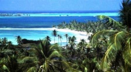
The Archipelago of San Andrés is located in the northwest of Colombia, on the sea of the Antilles. It is made up of the Islands of Providencia and Santa Catalina; the Islets Bolívar, Alburquerque, Cotton Haynes; the Grunt, Jhony Rose, Easycay, Roncador, Serrana, Serranilla, Quitasueño, Brothers, Rocky, Crac, Santander keys, and the Alicia and Bajo Nuevo banks.
The Island of San Andrés (also known as San Andrés Island) is the largest of the islands that are part of the Archipelago of San Andrés, Providencia and Santa Catalina, with its total extension of 26 km. It has belonged to Colombia since 1803 when Spain annexed it politically and administratively to the then Viceroyalty of New Granada through the Royal Order of San Lorenzo, in such a way that when this territory became independent around 1819, the islands were immediately annexed by their own will to present-day Colombia.
San Andrés is located in the Caribbean Sea, about 191 kilometers east of Nicaragua and northeast of Costa Rica and 775 kilometers northwest of the Colombian coast. The 26 km of surface make it the largest island in the archipelago. Providencia, the next largest island, is located 80 km to the northeast.
The islands of the archipelago have a warm climate that oscillates between 26 ° C and 29 ° C where two seasons predominate, summer and winter. The winds help a little to alleviate the heat, generally blowing from the east, and when storms occur in the Caribbean the winds blow strongly from the northeast. In general, during the year the rains are definitive for a dry season and a rainy one, the first one has a variable duration that can reach five consecutive months while the following months are rains, with strong winds at the end of the year.
Floors
San Andrés is crossed from south to north by a small mountain range whose maximum height is found in the La Loma hill, about 85 meters high. The soils of San Andrés indicate that its formation is due to the eruption of an ancient volcano that threw rocks from the seabed to the surface, creating most of the islands of the archipelago.
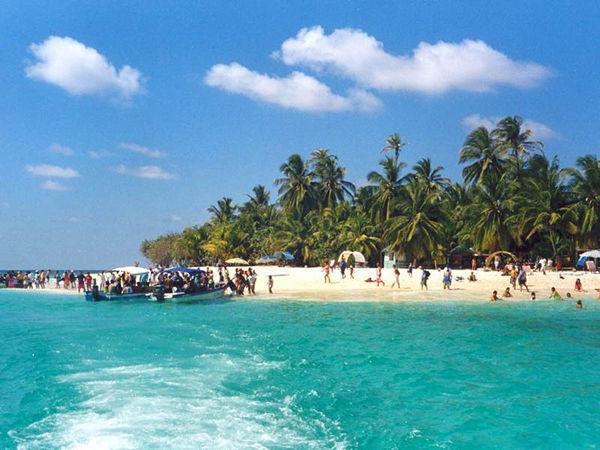
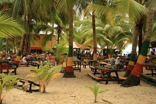
Likewise, the island is surrounded in its northwestern part by a small coral reef and several keys that are home to varied marine fauna and flora, which is why they are visited by many tourists every year.
Populations
North End (City of San Andres) is the main urban nucleus, where the departmental administration, commerce, banks, several hotels and the airport are located. In the neighboring bay of San Andrés, the port of El Cove operates. La Loma is another urban nucleus, inhabited by the Raizal population, it is located in the center of the island characterized by a chain of hills (Flowers, Orange, Shingle and Lion's Hill). To the south of the island is San Luis, a Raizal town, which now also includes tourist establishments.
Sports in San Andrés Island:
All or almost all, especially the aquatic ones that can be practiced in the Archipelago. Diving finds magnificent settings in San Andrés. There are PADI and NAUI certified schools. Sailing sports such as Sunfish, Katesurf and Windsurf are practiced and taught in the breezy months: December, January, February and in the middle of the year. Ski and Jet ski are other sports possibilities. Cycling and athletics allow you to travel the Island along its coast or along its mountain paths.
"Beach Volleyball is also practiced on different beaches in San Andrés."
The natives play basketball and baseball. They are also fond of horse races, which they organize on the Elsy Bar road, in the south of the island.
National holiday: July 20 parade in the center of the city and August 7 in San Luis.
September: Festival of the Green Moon.
October: Festival of Religious Choirs, October 12, Columbus Day in the La Loma sector; International Theater Festival "Ethnic Roots".
November: Anniversary Parties, Reinado del Coco, Patron Saint Festivities of San Andrés and Tub e Horse Jaw Bone Festival.
Comments
We don´t have yet any comments about:
San Andrés Island
San Andrés Island
Be the first to leave a comment as it is very important to inform other people
Outros locais a visitar
Within a radius of 20 km from:San Andrés Island
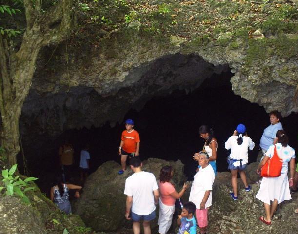
Morgan's cave |
| 0,2 Km |
 |
Casa Museo Isleña |
| 1,4 Km |
 |
West View |
| 2,5 Km |
 |
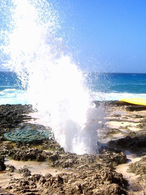
Blower Hole |
| 3,2 Km |
 |
Haynes Cay |
| 3,6 Km |
 |
The Far Keys |
| 4,3 Km |
 |
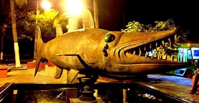
Barracuda Park |
| 4,3 Km |
 |
Spratt Bight Beach |
| 4,8 Km |
 |
Johnny Cay Regional Park |
| 6,5 Km |
 |
Hotel reservation near San Andrés Island within a radius of 20 km

Why to book with TOURISTIC ROUTES
The best prices
Our partnerships with the world´s largest operators offer research on the best market prices.
More options
At Rotas Turisticos you can book the hotel, buy the air ticket, book the transfer from the airport to the hotel and vice versa, book the local excursions, rent the car, take travel insurance and consult the places to visit and where to go.
Holiday Tips & Destinations
Hundreds of holiday destinations with all the options that allow you to easily choose the destination that best suits your dream vacation.
TOURISTIC ROUTES
Links
Follow us on social networks


