Salamanca Island Park


, Magdalena, Colombia
Suggest Place to Visit
785
Track to location with GPS |
 |
The protected area has been called Vía Parque because the highway that connects Santa Marta with Barranquilla runs through it.
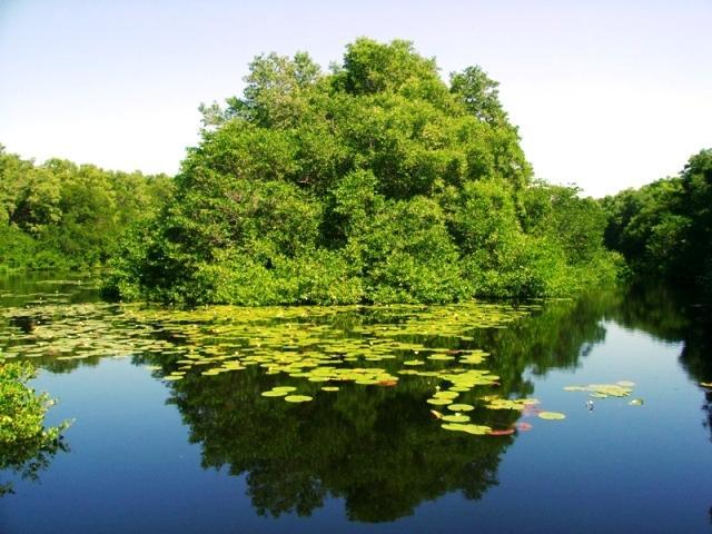
The Island of Salamanca is actually a set of small islands separated from each other by narrow channels that were formed in the Pleistocene by accumulation of sediments from the Magdalena River, whose height does not exceed 6 meters above sea level. These islands make up the natural barrier that separates the Ciénaga Grande de Santa Marta from the Caribbean Sea while maintaining water exchange. However, the embankments of the highway, which was built some time before being declared a protected area, have hampered the water dynamics and caused a high level of saltiness in the swamp. In the same way, the clogging of the cabales that join the Magdalena and the Ciénaga aggravates the situation, it is for this reason that in many parts the mangrove has died.
The freshwater swamps are quite productive, on their shores grow jaguars, reeds and other floating grasses, which are an important supply station for migratory birds.
The climate is quite arid and dry, with an average temperature of about 28.5 ° C. The volume of water that plants lose through evaporation and transpiration is greater than the rains, which is why they take it from nearby estuaries and lagoons. Trade winds from the north ease the hot climate in the area somewhat.
The Island of Salamanca and its surroundings are the old Magdalena delta, formed by the sediments that the river brings from the interior of the country in its channel and its formation being parallel to that of the same. It is assumed that about 30 million years ago the Sierra Nevada de Santa Marta was raised by means of tectonic movements and created the Magdalena estuary.
Most of the area is covered in mangrove, dry forest, and riparian (or riparian) forest. The flora depends on several factors such as the salt in the soil, the rainfall, the duration of the floods, the winds, the evaporation, etc. Above all, trees with thorns on the trunk predominate.
The mangrove of Salamanca is an open ecosystem that imports nutrients from the Magdalena sediments and exports organic matter in the form of shrimp, oysters and fish. Its relationship with fishing productivity is fundamental. Towards the west there is a riverside forest with trees of cantagallo, uvito, palmicho and others. On the mainland there are typical forests dominated by legumes such as trupillo, aromo and acacia, as well as some cacti.
Departure from Barranquilla to Ciénaga. The Vía Parque is located approximately at 10 ° 56´ North and 74 ° 27´ West, in the territory of the department of Magdalena, in the jurisdictions of the municipalities of Ciénaga, Pueblonuevo and Sitionuevo.
Its limits are to the north the Caribbean Sea, to the east the Ciénaga Grande de Santa Marta, to the south the Caño Clarín Nuevo and the Ciénaga Pajaral and to the west the Magdalena River.
It was declared a national park due to its natural, economic and cultural characteristics, which deserve to be protected. It protects the most significant mangrove area in the Colombian Caribbean.
Comments
We don´t have yet any comments about:
Salamanca Island Park
Salamanca Island Park
Be the first to leave a comment as it is very important to inform other people
Outros locais a visitar
Within a radius of 20 km from:Salamanca Island Park
Unfortunately we do not have information on other places to visit in this area yet
Hotel reservation near Salamanca Island Park within a radius of 20 km
No results
Why to book with TOURISTIC ROUTES
The best prices
Our partnerships with the world´s largest operators offer research on the best market prices.
More options
At Rotas Turisticos you can book the hotel, buy the air ticket, book the transfer from the airport to the hotel and vice versa, book the local excursions, rent the car, take travel insurance and consult the places to visit and where to go.
Holiday Tips & Destinations
Hundreds of holiday destinations with all the options that allow you to easily choose the destination that best suits your dream vacation.
TOURISTIC ROUTES
Links
Follow us on social networks


