Chocontá


Almeidas, Cundinamarca, Colombia
Suggest Place to Visit
503
Track to location with GPS |
 |
Founded date: September 06, 1538
The new town of Chocontá was founded on a hill on the other side of the Funza River, opposite the current one in 1563 by order of the judge TOMÁS LOPEZ, from where it was transferred to the current site in 1573.
Historical review:
CHOCONTA in the Chibcha language means: "Farm of the Good Ally", in pre-Columbian times it was the stronghold of the Zipas. The Spanish arrived in our town in aboriginal times on June 9, 1537, the day that Pentecost was celebrated, then Father Fray Domingo de las Casas celebrated a mass, who named it ´´Pueblo del Espíritu Santo´´. The town was located opposite the current one, on the other side of the Funza river, where today is Pueblo Viejo.
The new town of Chocontá was founded on a hill on the other side of the Funza River, opposite the current one in 1563 by order of the judge TOMÁS LOPEZ, from where it was transferred to the current site in 1573.
Its foundation was in 1563 and its Founder the oidor Tomás López. Gonzalo Jiménez de Quezada visited our municipality in 1537. In 1854 it was the presidential seat and on April 21 of that same year, Tomás Herrera was proclaimed President of the Republic in the Cural House of our town, on August 9, In 1819, at two in the afternoon, the Liberated Simón Bolívar arrived in Chocontá and stayed to rest where today is the House of Culture after the triumph obtained, defining the fate of our republic.
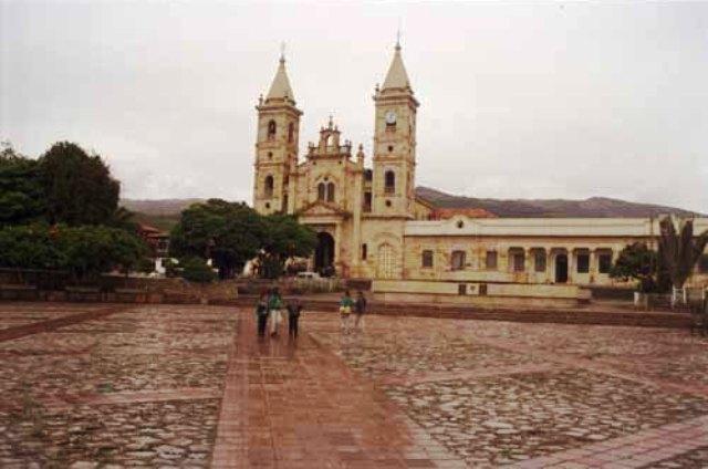
La Leal y Noble Villa de Santiago de Chocontá, better known by tourists as Chocontá is a municipality of Cundinamarca (Colombia), located in the province of Los Almeidas, it is located 75 km from Bogotá. Chocontá in the Chibcha language means tillage of the good ally. In pre-Columbian times it was the stronghold of the Zipas. The Spanish arrived at the aboriginal town on June 9, 1537, the day of Pentecost, a feast celebrated with a mass by Father Fray Domingo de las Casas, who gave himself the name of Pueblo del Espíritu Santo. The town was located opposite the current one, on the other side of the Funza river, a place that today is called Pueblo Viejo.
Physical description:
The municipal head is located at 5 ° 09 'of North Latitude and 73 ° 42' of West Longitude, on a height above sea level 2,655 m. and average temperature 13 ° C.
Limits of the municipality:
It limits by the North with the municipalities of Lenguazaque and Villapinzón; to the West with Suesca; to the South with Sesquilé and Machetá and; to the East with the municipalities of Villapinzón, Tibirita and Machetá.
Total extension: The municipality has a territorial extension of 301.1 Km2 Km2
Urban area extension: 1.44 Km2 (0.48%) correspond to the urban area Km2
Rural area extension: 299.66 Km2 (99.52%) to the rural sector. Km2
Altitude of the municipal seat (meters above sea level): 2655
Average temperature: 13ºº C
Reference distance: 75 Km
Ecology
Most of the territory is mountainous but it also has extensive flat areas, mainly in the vicinity of the Bogotá River. Among the orographic accidents, the Suratá mountain range, the Chibalá hills, the June or Manacá ravines, El Ratón, Carnicerías and Saucío, among others; the mountains of Las Vueltas and the Altos del Arrastradero and Chilabá. Most of its lands correspond to the cold thermal floor and are watered by the Bogotá, Tejar and Sisga rivers, the latter forming the Reservoir of 96,400 million cubic meters.
The rural sector is made up of 22 villages: Guanguíta, Hato Fiero, Capellanía, Pueblo Viejo, Agua Caliente, Backpack, Plank, Apartments, Turmal, Retiro de Blancos, Retiro de Indios, Chingacío, Soatama, Tejar, Veracruz, Manacá, Cruces, Santa Barbara, Chinatá, Saucío, Boquerón and Tilatá
Economy
Economic activities
Primary sector
Agricultural Activities
70% of the population of Chocontá is dedicated to agricultural activities, thus occupying the first line of the municipality's economy.
The main agricultural product and the largest area planted in the municipality of Chocontá, is the potato crop with 850 Ha., Its yield is estimated between 15 and 20 tons per hectare (120 - 160 loads of 10 arrobas each), its yield decreases. production especially during times of frost and due to disease and pests. The main disease that attacks this crop is gout, caused by the fungus Phytophthora infestans; Other pests include the white worm (Premnotrypes Borax), the chiza (Ancognata scarabaoides), the fleas (Epitrix spp.) and the Guatemalan potato moth.
Currently, farmers in the area have improved varieties highly resistant to gout, which produce high yields and are of good quality; Among them, the Parda Pastusa, Diacol Monserrate, Diacol Guadalupe and Ica-Puracé varieties stand out. The variety most used in the municipality of Chocontá is Parda Pastusa.
Although genetic improvement and the introduction of modern agronomic practices have allowed obtaining higher yields per unit of cultivated area with potatoes and vegetables, these have not been generalized. The explanation is associated with the organizational aspect of exports, the importation of precooked (frozen) potatoes, the concentration of production in a few hands, the mentality of the producers, and the structure and behavior of the market.
Papiculture is unevenly distributed in terms of production, marketing and income distribution conditions. In this sense, it is possible to identify different types of producers according to their financial capacity or mentality.
The ICA classifies regional paper farmers into two groups: small and medium-large. The former, on the way to extinction, are located in the steepest area, operate in smallholding conditions (2.2 hectares per farm), use family labor force, have cultural behavior and economic limitations that prevent them from introducing the scarce technology that the support units put at their disposal, apply the programmed chemical control and depend on the meteorological conditions for the success of the crop. These factors are decisive so that only 12 tons are obtained on average. of product per hectare and so that they are exposed to strong price fluctuations, which translates into a participation of only 12% in the gross value.
On the contrary, the group of medium-large, despite representing only 46% of the papiculturists in the region, controls 82% of the cultivated area and 88% of the product, has average farms of 11 Ha. Its own financial and credit resources that allow it to adopt the technology offered by ICA, it has sources and infrastructure for irrigation, it obtains average yields of 18 Ton./Ha. and receives better prices due to its better location and high negotiation capacity.
The villages in the municipality where the greatest amount of potato is grown are Hato Fiero, Guanguíta, Cruces, Tilatá, Soatama, Tejar and the Suralá sector. The local economy presents instability with respect to this crop since it depends on the fluctuation of prices offered by the market.
Other crops of interest are legumes; the pea that is carried out especially in the villages of Tilatá, Tablon, Hato Fiero, Pueblo Viejo and Capellanía, generates a yield of 4 tons per hectare; The cultivation of broad beans was carried out in the villages of Mochila, Agua Caliente, Hato Fiero, Tablon and Capellanía with a higher yield of 8 tons per hectare.
Strawberry cultivation with a yield of 28,000 tons per hectare is carried out in the Retiro de Blancos, Tablon, Agua Caliente, Veracruz and Retiro de Indios villages.
The agricultural activities of the region are going through a crisis, since the area dedicated to these tasks and the supply of water have decreased, with the aggravating factor that the production of cereals tends to disappear from the agricultural panorama, the involution of the cereal activity is related to economic factors of regional, national and international character and with the phytosanitary problems of the crops. Added to this is the ostensible population decline in the Sabanero fields, which has migrated in search of better income and quality of life, working in industry and in the formal and informal tertiary sector.
Celebrations
Holy Week.
Chocontá's birthday is celebrated on September 7, because on September 7, 1810, Chocontá was consolidated as a municipality.
Peasant's Day does not have a fixed date for its celebration, but the municipality organizes it with mass, cultural events, bullfight, lunches and gifts for the peasants.
tourism
Los Volcanes Hot Springs
Country Houses and Los Sauces Hot Springs
Chapel of the Holy Christ (humilladero)
Sisga reservoir
Train station
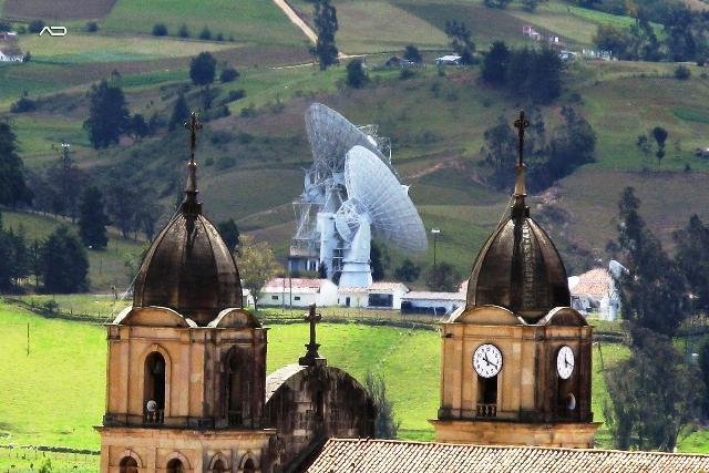
Ground station
city Hall
Telecom parabolic antennas, for this reason it is called ´´CIUDAD SATELLITE DE COLOMBIA´´
Main producer of strawberries (frutilla) in Colombia and annually celebrates the national reign of the strawberry
Comments
We don´t have yet any comments about:
Chocontá
Chocontá
Be the first to leave a comment as it is very important to inform other people
Outros locais a visitar
Within a radius of 20 km from:Chocontá
Villapinzón |
| 12,0 Km |
 |
Hotel reservation near Chocontá within a radius of 20 km

Why to book with TOURISTIC ROUTES
The best prices
Our partnerships with the world´s largest operators offer research on the best market prices.
More options
At Rotas Turisticos you can book the hotel, buy the air ticket, book the transfer from the airport to the hotel and vice versa, book the local excursions, rent the car, take travel insurance and consult the places to visit and where to go.
Holiday Tips & Destinations
Hundreds of holiday destinations with all the options that allow you to easily choose the destination that best suits your dream vacation.
TOURISTIC ROUTES
Links
Follow us on social networks


